Elba pole detection layers
Detections
Utility sheets, reference only
fade75%
Reference
km80%
Display
Imagery100%
Marker9
Imagery 2020-04-25, 0.51 m. LiDAR USGS 3DEP 2021.
Circuits traced from the utility routing map, georeferenced to about 20 m,
so they show which roads are energised, not where a pole stands.
Poles accepted at FDR 10%.
Utility map symbology
| 3Ø primary | traced | |
| 2Ø primary | traced | |
| 1Ø primary | traced | |
| Highway & road R.O.W. | use OSM | |
| Rivers and streams | skipped | |
| City limits | skipped | |
| 25 kVA transformer sheet 1 | pole! | |
| UG riser pole | pole! | |
| Fusible switch | pole! | |
| Gang operated switch sheet 1 | pole! | |
| Capacitor, sub #1 | pole! | |
| Capacitor, sub #2 | pole! | |
| Underground (UG) | no poles | |
| OH | Overhead | has poles |
| Circuit designation, load flow, voltage drop sheet 1 | topology |
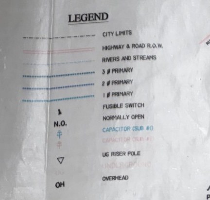 Sheet 2, colour circuit map. The layer actually traced.
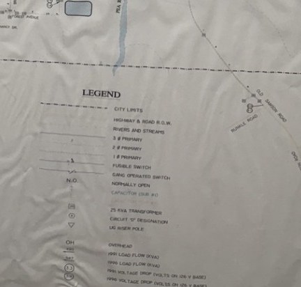 Sheet 1, 1996 load-flow study. Adds transformers, gang switches and
circuit designations. Not yet extracted: at 5.5 m per map pixel a
transformer symbol is about 4 px, too coarse to separate from a number.
Sheet 1, 1996 load-flow study. Adds transformers, gang switches and
circuit designations. Not yet extracted: at 5.5 m per map pixel a
transformer symbol is about 4 px, too coarse to separate from a number.